
drawing o-map Glarisegg
28Jan07 21:50 Filed in: Hobby
after finishing fieldwork of the new to be released orienteering map Glarisegg I needed a short break (Xmas time). But now it is time to draw this map. I am doing this on my Mac using Adobe Illustrator together with MapStudio.
After one and a half week I could finish the first and most important part of the map (see picture):
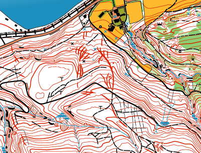
Glarisegg contour lines (brown)
Having the contour lines together with cliffs and rocks watecourses roads and pathes makes more than half of the map. Now only the vegetation (green color) is missing. This gives information about the runnability to the competitors. On the upper right corner you see the already existing part of the o-map Eichhölzli done by Adi Moser last year.
After one and a half week I could finish the first and most important part of the map (see picture):
Glarisegg contour lines (brown)
Having the contour lines together with cliffs and rocks watecourses roads and pathes makes more than half of the map. Now only the vegetation (green color) is missing. This gives information about the runnability to the competitors. On the upper right corner you see the already existing part of the o-map Eichhölzli done by Adi Moser last year.
blog comments powered by Disqus